Home › Categories › Field data & mobile › Page 2
Field data & mobile QGIS plugins Page 2 of 3
QGIS plugins to collect data in the field and sync with mobile apps. 126 plugins, 67 QGIS 4 ready, 92 actively maintained. Sorted by downloads. Showing 61–120.
Related categories: Vector tools · Georeferencing & CAD · Spatial analysis · Web maps & export · Network & routing · All categories
- AutoUpdateTAXREFNot QGIS 4 ready
Plugin QGIS pour la mise à jour automatique des espèces et statuts via l'API TAXREF de l'INPN
- TaxRef CollectorQGIS 4 ready
Récupérer les identifiants TAXREF (cd_nom, nom_vernaculaire et url) de vos listes de taxons en fonction de leur nom, leur rang de leur ident
- LK-Technik Path PlannerNot QGIS 4 ready
Import and export guidance and field data for agricultural machinery — ISOXML (v3/v4), John Deere Gen4, and AgGPS in one plugin.
- NMEA VisualizerNot QGIS 4 ready
Visualize NMEA GNSS logs and optionally export to GPKG/SHP/KML
- PyXel_SyncNot QGIS 4 ready
PyXel_Sync
- WIMS IntegrateNot QGIS 4 ready
Aggregates WIMS field data with Web Services
- OrthoManagerQGIS 4 ready
Orthophoto inspection tool with VRT management, inspection right-click menu, and ZXCV drawing shortcuts
- TairuDBQGIS 4 ready
Connect QGIS to Tairu Maps (https://tairumaps.com) for two-way cloud sync, editable field records, and offline .tairudb map generation.
- Field GuideQGIS 4 ready
Field routes, polygon sampling, raster-based optimal sampling points, CSV/GPX export and PDF reports in QGIS / Rotas de campo, amostragem po
- Go Data ExtractionNot QGIS 4 ready
This Plugin for QGIS enables users to log in to Go.Data and extract case data.
- Japan GSI Point CollectorNot QGIS 4 ready
This plugin collects points from gsi website
- MRF Translado GNSSQGIS 4 ready
Professional QGIS plugin for GNSS coordinate translation with integrated map visualization, PPP IBGE and SIGEF Memorial support, variance pr
- 3D Track ViewerQGIS 4 ready
适用于QGIS 3和QGIS 4的三维轨迹分析工具,支持工程点线图层、本地GPX、时间裁剪、关键帧动画,以及可配置格式、分辨率和动画参数的多格式导出。 / 3D track analysis for QGIS 3 and QGIS 4 with project layers, l
- KoboToolbox FieldBridgeQGIS 4 ready
Import KoboToolbox and ODK Central field survey data as QGIS vector layers. Supports geopoint, geotrace and geoshape. Incremental sync and a
- GeoLineageNot QGIS 4 ready
Track data lineage in GeoPackage files — records processing, edits, and exports automatically.
- photo location by time:写真の位置をGPXの時間で推定QGIS 4 ready
A plugin that estimates the location where a photo was taken by matching the photo's Exif data with the timestamps in a GPX file (track poin
- Survey Adjustment & Network AnalysisNot QGIS 4 ready
Least-squares adjustment for survey networks (2D, 1D leveling, 3D GNSS, mixed) with robust estimation, statistics, and reliability analysis.
- FileSyncNot QGIS 4 ready
Tools to sync directory-files with point-layer
- GPX Batch ConverterQGIS 4 ready
Batch-converts GPX layers to Shapefile, GeoPackage, GeoJSON, KML or CSV, with optional merging, background processing, cancellation and deta
- Photo To GeoJSONQGIS 4 ready
Converts photos with GPS information into a GeoJSON point layer.
- Bambi - QGIS IntegrationNot QGIS 4 ready
Detect and track wildlife in drone videos/photos with geo-referencing
- qfitQGIS 4 ready
Explore fitness data spatially in QGIS
- LookaheadQGIS 4 ready
Plan, optimize, and simulate OBN source-line acquisition in QGIS with interactive sequence editing, directional turn control, and speed-awar
- Road Video TrackerQGIS 4 ready
View road survey videos synced with GPS tracks on the map
- ColorGPXQGIS 4 ready
GPX轨迹按速度/高度/坡度渲染及批量处理工具,支持工程图层、单个或多个GPX和extensions扩展字段。 / Render and batch-process GPX tracks by speed, elevation or slope from project laye
- Mapupdate360Not QGIS 4 ready
Use 360/equirectangular street-view images to visualize field context and update 2D GIS layer information.
- Wincan Vx to TEKSI ImporterQGIS 4 ready
Wincan Vx to TEKSI Importer allows importing Wincan Vx data into TEKSI wastewater module.
- Map-XQGIS 4 ready
Advanced spatial sync & compare tool with smart Z-ordering and real-time statistical legend (Lite Version).
- CartoDruid Device SyncNot QGIS 4 ready
Synchronize projects between CartoDruid and QGIS. Configurable for other device files.
- GPS Road Builder (RidgeSlide)QGIS 4 ready
Reconstructs a connected road/path network (graph) from raw GPS tracks using the RidgeSlide density method
- Dux HodosQGIS 4 ready
Navigate scattered vector point data feature-by-feature with highlight, sort, nearest-neighbour, area/raster filter and quick Y/N/D field ed
- MeridianQGIS 4 ready
Provides magnetic declination, grid convergence and grid magnetic angle for any location and date (1900–2030) — fully offline, using WMM, WM
- Photo2GeoJSONNot QGIS 4 ready
Creates a GeoJSON point layer from geotagged photos with azimuth direction, map tips and DJI drone support
- Lithica Cloud SyncNot QGIS 4 ready
Synchronize Lithica Explorer and Mapper projects from Google Drive | Sincroniza proyectos de Lithica Explorer y Mapper desde Google Drive
- gmqrNot QGIS 4 ready
Generate Google Maps URLs and QR codes from clicked map locations
- RouteCorrectorNot QGIS 4 ready
Corrects GPS drift and realigns mobile environmental sensor data along user-defined routes.
- GPX_AppenderQGIS 4 ready
Append GPX waypoints or tracks directly into existing project layers. Drag & drop GPX files or folders, pick a destination layer, configure
- Connector for KoboNot QGIS 4 ready
Connect to KoboToolbox to download form submissions as map layers, with intelligent geometry detection, searchable survey list, and layer sp
- Tramos sobre track (25830)Not QGIS 4 ready
Genera tramos sobre un track a partir de tabla (X/Y/Longitud/Tramo), todo en EPSG:25830. Incluye capa auxiliar y guardado a GPKG/SHP.
- PloverQGIS 4 ready
Boundary-aware Traveling Salesperson routing: shortest tour through your points, around your sloughs.
- QITVNot QGIS 4 ready
Plugin Qgis pour les inspection telévisée de réseaux d'assainissements - QGIS plugin for sewer CCTV inspections
- VTK ImporterNot QGIS 4 ready
Imports Velocitek .VTK files and converts them to CSV, GeoJSON or PostGIS
- CoastProfileQGIS 4 ready
Multiannual monitoring of beach and dune topographic profiles, GNSS quality control and erosion assessment.
- GeoSector Photo MapNot QGIS 4 ready
Manage, review and correct geotagged field photos directly in QGIS.
- Zone Blanche FinderNot QGIS 4 ready
Identifies white zones (poorly connected areas) based on a connectivity score calculated per municipality
- QGIS Deliverable InspectorQGIS 4 ready
Inspect QGIS projects for delivery risks and write read-only Markdown and JSON reports.
- Point Shift TrackerQGIS 4 ready
Track how far a point feature has been moved during editing, with live distance analysis and an in-panel warning when a shift exceeds your c
- GeoditQGIS 4 ready
Edit your Geodit survey area in QGIS and keep it in sync with the server (project owners, admins and editors).
- Recalculo RTK a Coordenadas AjustadasQGIS 4 ready
Recalculates field points collected against a "free" RTK base to the base's adjusted coordinates from static GNSS post-processing (plane and
- Precisa — Altitude Geoidal (hgeoHNOR2020)Not QGIS 4 ready
Geoid undulation and normal height via IBGE's hgeoHNOR2020 grid (BRAZIL). Automatic offline download (~2 MB), bilinear interpolation, CSV an
- Precisa — RBMC / Efemérides / PPKNot QGIS 4 ready
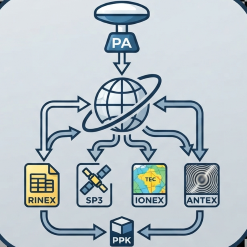
Automated download of RINEX, SP3, IONEX, ANTEX, hgeoHNOR2020 and a full PPK kit, with an optional AI co-pilot for ephemeris and RBMC (BRAZIL
- Precisa PerímetroNot QGIS 4 ready
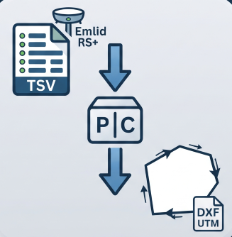
Reconstructs a boundary from Emlid RS+ TSV points (GTopo post-processed): detects chains, resolves duplicates, orders vertices and exports U
- GeoDipQGIS 4 ready
Automates the plotting of structural geology measurements (Dip and Dip-Direction).
- GeoPhoto Tri & AtlasNot QGIS 4 ready
Imports geotagged photos (EXIF GPS), creates the points on the map, sorts/copies the photos into folders named after polygon footprints, and
- PudumapsNot QGIS 4 ready
Connect QGIS to Pudumaps — Chilean geospatial cloud. Pull, push and sync projects and layers via the Pudumaps REST API.
- Geo360 ViewQGIS 4 ready
Review GPX-synchronized videos and save 360-space Markings in QGIS.
- Repoliner - репозитории модулейQGIS 4 ready
Builds a QGIS plugin repository (plugins.xml) from ready-made plugin archives. Собирает репозиторий модулей QGIS (plugins.xml) из готовых ар
- J3M IoT ConnectorQGIS 4 ready
Connect QGIS to J3M IoT data, collection sessions, and environmental indicators for geoprocessing and microclimate analysis.
- CRAGQGIS 4 ready
QGIS plugin for Collection and Reporting of Associated Geodata (CRAG). The plugin adds layers and tools for geological map data collection i
- Cross Section GeneratorQGIS 4 ready
This plugin generates a cross-section graph based on bore profiles.