
Home › Field data & mobile › Precisa Perímetro
Precisa Perímetro QGIS 4 compatibility
Not QGIS 4 ready Active
Not yet — the latest version declares max QGIS version 3.99.0, so it is not offered to QGIS 4 users.
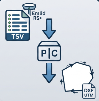
Reconstructs a boundary from Emlid RS+ TSV points (GTopo post-processed): detects chains, resolves duplicates, orders vertices and exports UTM DXF.
About
Motor de reconstrução de perímetro: lê TSV com pontos GNSS coletados em campo (Emlid RS+ pós-processado no GTopo), detecta cadeias por gap de tempo, resolve duplicatas, detecta pontos inseridos fora de sequência, reconecta cadeias minimizando cruzamentos e exporta DXF R2010 em UTM SIRGAS2000. Usa normalização unicode para compatibilidade de nomes.
| Author | Helton J. C. Lourenço |
|---|---|
| Downloads | 216 |
| Latest version | 1.8.0 |
| Last updated | 2026-08-02 (74 days ago) |
| Min QGIS | 3.16.0 |
| Max QGIS | 3.99.0 |
| QGIS 4 ready | No |
| Maintenance | Active |
| Categories | Field data & mobile, Georeferencing & CAD, Coordinates & projections |
| Tags | georreferenciamento, incra, tsv, gnss, sigef, perimetro, gtopo, emlid, rural |
Homepage · Repository · Issue tracker · Official page
Alternatives in Field data & mobile
- QField SyncQGIS 4 ready
Sync your projects to QField
- ImportPhotosQGIS 4 ready
Import Photos
- Mergin MapsQGIS 4 ready
Handle Mergin Maps projects



Related plugins
- MRF Translado GNSSQGIS 4 ready
Professional QGIS plugin for GNSS coordinate translation with integrated map visualization, PPP IBGE and SIGEF Memorial support, variance pr
- GeoINCRAQGIS 4 ready
Georeferencing of rural properties according to INCRA’s Brazilian technical regulations for land regularization.
- GeoRondôniaQGIS 4 ready
Tools for Georeferencing Rural Properties
- Gerador de MemoriaisNot QGIS 4 ready
Generates a georeferenced descriptive report from narrative text, a QGIS layer, or a SIGEF/INCRA PDF, including points and a polygon.
- EarthWorkQQGIS 4 ready
Earthwork quantities for sites and road corridors: weighted grid integration and end-area sections, void-ratio volume conversion, daylighted
- GeoDocs SIGEFNot QGIS 4 ready
Automated generation of technical documents for SIGEF/INCRA rural land regularization workflows.






Maintenance: Active = updated within 1 year, Quiet = 1–3 years, Likely abandoned = over 3 years.