Home › Categories › Georeferencing & CAD › Page 5
Georeferencing & CAD QGIS plugins Page 5 of 7
QGIS plugins to georeference, digitise and exchange CAD and survey data. 362 plugins, 145 QGIS 4 ready, 263 actively maintained. Sorted by downloads. Showing 241–300.
Related categories: Vector tools · Raster & terrain · Coordinates & projections · Spatial analysis · Field data & mobile · All categories
- PWA Live DistanceNot QGIS 4 ready
A real-time distance and area measurement tool while using the native Add Feature tools, designed for utility workflows.
- Polygon validator EUDR 2Not QGIS 4 ready
EUDR-oriented polygon quality-control suite: geometry repair and overlap cleaning, interior centroids with Longitude/Latitude, self-intersec
- NewQuickAzimuthPlusNot QGIS 4 ready
🧭 NewQuickAzimuthPlus: Digitize polygons by entering azimuth and distance values, or extract azimuth/distance from existing polygons.
- Street Facing SideNot QGIS 4 ready
Identifies the side of the polygon (e.g. parcels or building footprints) that is facing the street, river, or any other line vector file typ
- YF_Tools_PlusNot QGIS 4 ready
Unified plugin for surveying: create polygons from Excel/CSV, segment them with azimuth/angle calculations, and export to Excel with one cli
- GeocodificaCatastaliSardegnaNot QGIS 4 ready
Il plugin consente di ricercare ed esportare le particelle catastali relative al territorio della Regione Sardegna. Nota: in caso di problem
- PointScreenShoterQGIS 4 ready
Exports georeferenced map screenshots centered on point features at a chosen scale.
- GML to DXF (CityGML LoD2)Not QGIS 4 ready
Converts CityGML LoD2 building files (e.g. from BayernAtlas) to DXF 3D faces for CAD use.
- GeoBan FranceQGIS 4 ready
Search French addresses (BAN) and IGN cadastral parcels with GIS tools and A4 print layout.
- GeoDocs SIGEFNot QGIS 4 ready
Automated generation of technical documents for SIGEF/INCRA rural land regularization workflows.
- Linderos360COQGIS 4 ready
Generador de descripciones de linderos, plano cartográfico y tablas de coordenadas para los procesos catastrales colombianos (normativa del
- Coleta RuralNot QGIS 4 ready
Imports Coleta Rural PDF survey reports and other memorial descritivo formats (any Brazilian state), automatically creating polygon features
- CanaPlan – Réseau AssainissementQGIS 4 ready
Dessin topologique de réseaux EU (rouge), EP (bleu) et eau potable AEP (cyan, symboles StaR-Eau) : conduites, branchements, regards, taboure
- EastingQGIS 4 ready
Turn recorded deeds, easements, plats, and as-builts into validated parcel geometry. Easting extracts every boundary call with the source te
- Mapdex for QGISQGIS 4 ready
Nivo AI assistant for QGIS: ask questions about your layers and PostGIS in plain language, get measured spatial analysis on the map, run Pro
- Jeomatik NCZ ReaderQGIS 4 ready
Imports NetCAD NCZ drawing files into QGIS and converts supported entities into editable vector layers.
- Universal Vector ConverterNot QGIS 4 ready
Batch converts vector layers and directories into GeoJSON, KML, GPKG, FlatGeobuf, SHP, and DXF with CRS reprojection support.
- IVRNot QGIS 4 ready
Residential Vulnerability Index (IVR) analysis using cadastral and spatial data
- Precisa — DWG Batch ConverterNot QGIS 4 ready
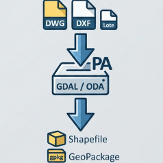
Batch conversion of DWG/DXF to Shapefile or GeoPackage via GDAL, with fallback to ODA File Converter for natively unsupported DWG files.
- PBZPA/PBZPHNot QGIS 4 ready
Geração de Plano Básico de Zona de Proteção de Aeródromo (PBZPA) e Heliponto (PBZPH) com análise de imagem de satélite, identificação de OPE
- HoleInnerNot QGIS 4 ready
Hole vs Inner Feature digitizing tool with options panel, attribute form, improved preview, snapping and undo-friendly behavior.
- Georeferencer AutosaveQGIS 4 ready
Automatically saves GCP points while working in the QGIS Georeferencer, preventing loss of work from crashes or accidental closure.
- Topology Error Creator & FixerQGIS 4 ready
Safely detect, create and repair vector topology errors including invalid geometries, duplicates, polygon overlaps/gaps, and line overshoot/
- AL Modify MonitorQGIS 4 ready
Automatically tracks geometry modifications and marks status via customizable hotkeys for multi-layer QC.
- Conduit Dynamic BufferNot QGIS 4 ready
VARIABLE WIDTH BUFFER
- Japan Land Survey AssistantQGIS 4 ready
Integrated tool for Japanese cadastral survey: MOJ XML loading, Kokudo Suuchi Info, cadastral progress visualization, parcel search, and lan
- TopoTidyNot QGIS 4 ready
Turn messy vector data into clean topology in QGIS: cleanup tools (snap, trim, extend, split, dissolve, fix geometry, simplify, remove dupli
- Ineffable ToolsNot QGIS 4 ready
A comprehensive suite of QGIS tools for power grid and infrastructure workflows.
- Survey Helpline ProNot QGIS 4 ready
Survey & Land Records and SVAMITVA, GIS automation toolkit for parcel, shapefile processing and map generation
- TopoQGIS 4 ready
L'outil "Topo"/"Topo" tool
- OS MasterMap GML to CADQGIS 4 ready
Convert Ordnance Survey MasterMap GZ/GML tiles into CAD-ready DXF drawings with intelligent symbolisation and British National Grid tiling.
- EchoCadQGIS 4 ready
Import DXF drawings into QGIS with CAD layers, colours, line types, hatch patterns and text intact. DWG is opened directly by EchoCad Pro.
- VernierQGIS 4 ready
Vector editing toolkit: smart snapping, topology validation, polygon splitting to exact areas, attribute and spatial joins, DXF/DWG and KMZ
- MunicipalityUnitsUnsnappedLinesNot QGIS 4 ready
Detects road network lines that do not anchor properly at municipal boundaries.
- toggle_layer_on_offNot QGIS 4 ready
Quickly toggle any selected layer ON or OFF with a single click in QGIS.
- MeridianQGIS 4 ready
Provides magnetic declination, grid convergence and grid magnetic angle for any location and date (1900–2030) — fully offline, using WMM, WM
- Photo2GeoJSONNot QGIS 4 ready
Creates a GeoJSON point layer from geotagged photos with azimuth direction, map tips and DJI drone support
- Georef-ArNot QGIS 4 ready
Complemento oficial para acceder a las funcionalidades de la API Georef desde QGIS.
- Compass Traverse GISQGIS 4 ready
Compass survey entry, traverse computation, and initial survey output in QGIS.
- Advanced Profile ToolNot QGIS 4 ready
Alignment-based cross-section generation, multi-DEM profile extraction, interactive section viewer, terrain comparison, volumes, and CAD/rep
- QCT GIS2DXF ExporterNot QGIS 4 ready
QGIS to AutoCAD DXF export: vectors and rasters in one drawing. Orthophotos and hillshades attach as georeferenced image xrefs, clipped to a
- Portal - FORGEGEONot QGIS 4 ready
Plugin central do Forgegeo/Geoservico para suporte técnico a processos do Cadastro Ambiental Rural (CAR), GeoNexus 1.16, Mosaic Clipper mult
- Vectorel Digitizer Pro QGIS3Not QGIS 4 ready
Vectorel Digitizer Pro QGIS3 is a QGIS plugin for creating and editing vector features by entering, pasting or modifying numerical vertex co
- MJ Chainage DrawNot QGIS 4 ready
Draw continuous polylines with exact chainage inputs and optional click-to-distance auto calculation.
- Israel TransCAD FixQGIS 4 ready
Fixes coordinate shift when importing TransCAD layers into QGIS (Israel ITM)
CAD Fillet & Chamfer suite with Interactive vertex rounding, Two-Line merge, Corner Restoration, and Batch processing for QGIS.
- Geo Crop RefNot QGIS 4 ready
Crops scanned maps/plans visually before Georeferencing and auto-loads them into the Georeferencer.
- Field Boundary ToolsQGIS 4 ready
Select a state, county, and local data folder to create an agronomic field-boundary layer with automatic input discovery.
- ML Generator SR/CRQGIS 4 ready
Generate map sheets for Slovakia and Czechia from polygon geometry or a layer bounding box.
- Cadastral Parcel ExtractorNot QGIS 4 ready
Identifies all cadastral land parcels affected by transmission line safety corridors using native QGIS processing algorithms.
- QGIS Time TrackerNot QGIS 4 ready
Track real active working time, tool usage statistics, editing activity, and productivity reports inside QGIS.
- DDM Line DirectionQGIS 4 ready
Overlay and animate lines/polylines with per-field arrowhead styling.
- Network TopologyQGIS 4 ready
Toolkit to clean and build the topology of line networks (roads, rivers, pipelines, railways).
- UA IN4 importerNot QGIS 4 ready
Import information from a Ukrainian cadastral exchange file (IN4)
- IGN DigitizingDirectionQGIS 4 ready
Displays the digitizing direction of features by drawing directional arrows, making it easier to verify geometry orientation during editing
- UgsurvNot QGIS 4 ready
CAD-style survey drafting and editing toolkit for Uganda land and boundary survey workflows.
- MJ-ChainageNot QGIS 4 ready
Calculate chainage values for point features along selected line layers
- Генератор укосівNot QGIS 4 ready
Автоматизована побудова укосів, обривів та підпірних стінок
- Parallel Folds & Structural ToolQGIS 4 ready
QGIS plugin for parallel fold digitization & geological cross-sections.
- Japanese Area UnitNot QGIS 4 ready
Converts area values between metric (square meters, hectares) and traditional Japanese units (tsubo, se, tan, cho).