Home › Categories › Spatial analysis › Page 2
Spatial analysis QGIS plugins Page 2 of 8
QGIS plugins to run statistics, interpolation and spatial modelling. 450 plugins, 159 QGIS 4 ready, 284 actively maintained. Sorted by downloads. Showing 61–120.
Related categories: Raster & terrain · Vector tools · Remote sensing · Network & routing · Hydrology & water · All categories
- Tree Density CalculatorNot QGIS 4 ready
The Tree Density Calculator is designed to calculate tree densities based on local maxima.
- QGeoloGISNot QGIS 4 ready
Visualization of well logs in QGIS
- Quick LayerNot QGIS 4 ready
Switch between the images of your choice using your favour keys how shortcuts.
- ClusterMapNot QGIS 4 ready
Receives polygon shapefile as input and applies clustering methods for the generation of choropleth maps
- ProcessXNot QGIS 4 ready
This Plug-In adds a new processing provider to QGIS. It contains a great variety of different processing algorithms.
- Standard DistanceNot QGIS 4 ready
Calculate and representate the position standard deviation of a set of features.
- Spatial AnalyzerNot QGIS 4 ready
Spatial Analysis Tools
- Cluster AnalysisNot QGIS 4 ready
Perform attribute based clustering on vector layers
- SciPy FiltersQGIS 4 ready
Filter collection implemented with SciPy
- Geomeletitiki Basin Analysis ToolboxNot QGIS 4 ready
Semi-automated Hydrological Basin Analysis toolbox.
- MODIS_NITKNot QGIS 4 ready
Plugin to process MODIS data available in HDF Format to user friendly GeoTiff (.tif) format and provide an option for Time Series analysis o
- Species ExplorerQGIS 4 ready
Quickly fetch and visualize species occurrence data from GBIF.
- Artificial Intelligence Forecasting Remote SensingNot QGIS 4 ready
This plugin allows time series forecasting using deep learning models.
- FS3Not QGIS 4 ready
Quickly generate, display, and compare basic statistics and graphs for numeric and text fields of vector layer(s)
- QProtoQGIS 4 ready
Rockfall analysis plugin based on the Cone Method
- InSAR ExplorerQGIS 4 ready
InSAR Explorer is a QGIS plugin for interactive visualization and analysis of InSAR time-series data.
- SSAMQGIS 4 ready
Spatial Sustainability Assessment Model (SSAM)
- Forest Roads NetworkNot QGIS 4 ready
A plugin to create a vectorial network of forest roads of different types according to the flux of timber going through them.
- maps2WinBUGSNot QGIS 4 ready
a tool to facilitate data processing for Bayesian spatial modeling
- GraphabNot QGIS 4 ready
Graphab for QGIS
- EDE InterpolationNot QGIS 4 ready
Evidence Density Estimation (EDE) interpolation of archaeological settlement data.
- Zonal Exact ExtractNot QGIS 4 ready
Zonal Statistics of rasters using Exact Extract library
- Extreme Value Classification for PolygonNot QGIS 4 ready
Task-Oriented Data Classification for Choropleth Maps <br/> Pre-request python packages: fiona, shapely, pysal, rtree, sklearn, dbf
- Spatial Query With ValuesNot QGIS 4 ready
Get maximum or minimum vector features for each polygon in an intersecting layer.
- QGISConeforNot QGIS 4 ready
A QGIS plugin to integrate with the Conefor landscape conectivity analysis software.
- Geographical detectorNot QGIS 4 ready
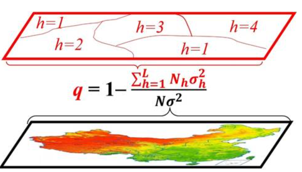
A tool for measuring spatial stratified heterogeneity and spatial associations of geographical attributes
- WAPluginNot QGIS 4 ready
Provides access to all the WaPOR data and includes it in the QGIS canvas as another raster layer, providing WaPOR data easy access to the QG
- Hotspot Analysis v3QGIS 4 ready
Advanced detection of hotspots, coldspots, and spatial clusters. Implements Getis-Ord Gi, Local Moran’s I (Univariate), and Local Moran’s I
- Least-Cost-Paths NetworkNot QGIS 4 ready
Compute the network of Least-Cost Paths between multiple origins and destinations based on a cost surface map
- GWAT - Watershed Analysis Toolbox by GeomeletitikiNot QGIS 4 ready
Semi-automated Hydrological Basin Analysis toolbox.
- RadiotrackNot QGIS 4 ready
Visualizes radiotracking data
- 02viz - Geospatial Visualization StudioQGIS 4 ready
Geospatial data visualization studio: multi-engine, interactive, publication-quality charts from QGIS layers and external data.
- StreetAnalysisNot QGIS 4 ready
Analysis for Streets
- Polygon Cluster ReducerNot QGIS 4 ready
This plugin removes polygons from the cluster, based on the user parameters.
- EIS QGIS PluginNot QGIS 4 ready
Comprehensive mineral prospectivity mapping and analysis framework
- Isoliner - грид и изолинииQGIS 4 ready
2D kriging (GSLIB KB2D) and isoline / contour-polygon generation in QGIS. Кригинг 2D (GSLIB KB2D) и построение изолиний/контурных полигонов
- Download Statistics Portugal Open DataNot QGIS 4 ready
This plugin enables the open data download of geographical and statistical Information from Statistics Portugal
- Geovita GIS Processing providerQGIS 4 ready
Aims to bring different Geovita custom geological and geotechnical processing algorithms to QGIS
- VetEpiGIStoolNot QGIS 4 ready
QGIS plugin to support animal disease control measures
- Land Productivity Analysis Tool (LPAT)Not QGIS 4 ready
The plugin analyzes and assesses land productivity
- Nearest Neighbor Method for Linear Features (NNMLF)Not QGIS 4 ready
This plugin estimates the spatial distribution pattern of linear features.
- QGIS Shoreline Change Analysis ToolNot QGIS 4 ready
A plugin for Shoreline Change Analysis (SCA).
- WeißflächenkartierungNot QGIS 4 ready
The White Space Mapping Tool provides an innovative and customizable approach to identifying potential areas for the installation of solar a
- ClimaPlotsQGIS 4 ready
Fetch 40+ years of daily climate data from NASA POWER or Open-Meteo (ERA5) for any point and build interactive charts in QGIS: trends with M
- Weighted Multi-Criteria Analysis - WMCANot QGIS 4 ready
Displays raster’s pixels values to the user, making possible to assign weights for each raster and grades for each class within each raster.
- ViewDroneNot QGIS 4 ready
A QGIS plugin for viewshed analysis in drone mission planning
- Continuous Network Analysis (Processing)Not QGIS 4 ready
Processing plugin that adds several scripts to assist in decision making and validation of line-type vector networks by generating inconsist
- Wetland Vulnerability Analysis ToolNot QGIS 4 ready
Analyze wetland vulnerability
- Instituto Canario de Estadística (ISTAC)Not QGIS 4 ready
Official plugin of Instituto Canario de Estadística (ISTAC)
- NotebookQGIS 4 ready
Render and run Jupyter notebooks within QGIS in a dockable panel.
- CCTV MapperNot QGIS 4 ready
The plugin plots CCTV data from sanitary sewer pipe inspections
- Maxent ModelNot QGIS 4 ready
Maxent mapping adapter for QGIS. Adaptador de cartografía Maxent para QGIS
- Precision ZonesNot QGIS 4 ready
Create management zones from rasters using PCA and K-Means with Elbow and Silhouette metrics, plus resampling, variance-reduction analysis,
- eMapToolsNot QGIS 4 ready
This plugin propose retention trees and riparian buffer zones based on ecological values
- StripchartdrawerQGIS 4 ready
The plugin draws a stripchart for a selected value from a dataset.
- Title Plotter PHQGIS 4 ready
Plugin for plotting Philippine land titles from technical descriptions. By Isaac Enage (byZenterra).
- PyLUSATQNot QGIS 4 ready
The plugin allows to perform Land Use Suitability Analysis following vector-based routines.
- Imagine SustainabilityQGIS 4 ready
sustainability assessment tool based on geographic MCDA algorithms. Especially suitable for Natura 2000 sites, based on pyrepo-mcda package(
- LightPollutionToolboxQGIS 4 ready
Light pollution toolbox
- THYRSISNot QGIS 4 ready
THYRSIS (Transport HYdrogéologique Rapide Simulé en Insaturé et Saturé) is a plugin to simulate hydrogeological flow and transport of chemic