
Home › Spatial analysis › Geographical detector
Geographical detector QGIS 4 compatibility
Not QGIS 4 ready Likely abandoned
Not yet — the latest version declares max QGIS version 3.99.0, so it is not offered to QGIS 4 users.
A tool for measuring spatial stratified heterogeneity and spatial associations of geographical attributes
About
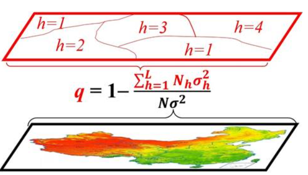
Spatial Stratified Heterogeneity (SSH) refers to the phenomena that the within strata are more similar than the between strata.Examples are land-use types and climate zones in spatial data. Geographical detector is a statistical tool to measure SSH and to make attribution for/by SSH; (1) measure and find SSH among data; (2) test the coupling between two variables Y and X and (3) investigate interaction between two explanatory variables X1 and X2 to a response variable Y.
| Author | Jiangang Guo; Jinfeng Wang |
|---|---|
| Downloads | 10,909 |
| Latest version | 1.3.0 |
| Last updated | 2022-05-06 (1624 days ago) |
| Min QGIS | 3.0.0 |
| Max QGIS | 3.99.0 |
| QGIS 4 ready | No |
| Maintenance | Likely abandoned |
| Category | Spatial analysis |
| Tags | spatial heterogeneity, stratification, geographical detector, spatial analysis, python |
Homepage · Repository · Issue tracker · Official page
Alternatives in Spatial analysis
- Group StatsQGIS 4 ready
Stats and analysis for vector layers data
- Data PlotlyQGIS 4 ready
D3 Plots for QGIS
- CrayfishQGIS 4 ready
Tools for mesh layers QGIS



Related plugins
- Stratified PackagerQGIS 4 ready
Exports vector layers to multiple geopackages split by attributes or spatial intersection
- Space Syntax ToolkitNot QGIS 4 ready
Collection of tools for space syntax analysis workflows in a GIS environment.
- Hotspot Analysis v3QGIS 4 ready
Advanced detection of hotspots, coldspots, and spatial clusters. Implements Getis-Ord Gi, Local Moran’s I (Univariate), and Local Moran’s I
- Create GridNot QGIS 4 ready
Plugin to create a grid of polygons within a selected polygon layer
- Sampling TimeNot QGIS 4 ready
Performs multiple sampling methods on shapefile layers
- UrbanMatrixNot QGIS 4 ready
Apply the Matrix Method to urban spatial data using a customizable classification and visualization workflow.




Maintenance: Active = updated within 1 year, Quiet = 1–3 years, Likely abandoned = over 3 years.