
Home › Raster & terrain › Classificador de Declividade
Classificador de Declividade QGIS 4 compatibility
Not QGIS 4 ready Active
Not yet — the latest version declares max QGIS version 3.99.0, so it is not offered to QGIS 4 users.
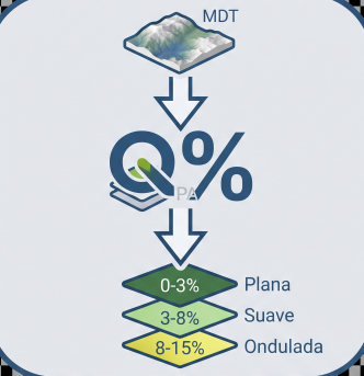
Classifies a DEM into polygons by user-defined slope ranges and calculates adaptive earthwork by class.
About
Processa MDT (GeoTIFF) via GDAL/QGIS: aplica filtro de declividade (gdal:slope), reclassifica em faixas configuráveis, vetoriza os polígonos resultado e exporta Shapefile. O módulo de Terraplanagem calcula o volume de corte/aterro por classe de declividade usando NumPy, e gera seções transversais e relatório de volumes.
| Author | Helton J. C. Lourenço |
|---|---|
| Downloads | 321 |
| Latest version | 1.0.0 |
| Last updated | 2026-08-02 (75 days ago) |
| Min QGIS | 3.16.0 |
| Max QGIS | 3.99.0 |
| QGIS 4 ready | No |
| Maintenance | Active |
| Category | Raster & terrain |
| Tags | dem, mdt, declividade, agrimensura, topografia, slope, raster, polígonos |
Homepage · Repository · Issue tracker · Official page
Alternatives in Raster & terrain
- Profile toolQGIS 4 ready
Plots terrain profile
- Qgis2threejsQGIS 4 ready
3D map visualization and web export powered by three.js JavaScript library
- SRTM-DownloaderQGIS 4 ready
Downloads SRTM Tiles from NASA Server


Related plugins
- MRF Translado GNSSQGIS 4 ready
Professional QGIS plugin for GNSS coordinate translation with integrated map visualization, PPP IBGE and SIGEF Memorial support, variance pr
- CAD Toolbar ProNot QGIS 4 ready
Toolkit CAD completo para QGIS — linha de comando estilo AutoCAD, curvas, geoprocessamento, transformações e exportação.
- Conversor UTM para SIG-RINot QGIS 4 ready
This tool automates the conversion of coordinate files from the UTM (Universal Transverse Mercator) projected system into the standardized G
- Gerador de MemoriaisNot QGIS 4 ready
Generates a georeferenced descriptive report from narrative text, a QGIS layer, or a SIGEF/INCRA PDF, including points and a polygon.
- Recalculo RTK a Coordenadas AjustadasQGIS 4 ready
Recalculates field points collected against a "free" RTK base to the base's adjusted coordinates from static GNSS post-processing (plane and
- ProfileMasterQGIS 4 ready
Longitudinal profiles, cross-sections, 3D axis, DTM buffer and contour lines from vector alignments or loaded QGIS layers over Digital Terra





Maintenance: Active = updated within 1 year, Quiet = 1–3 years, Likely abandoned = over 3 years.