
Home › Raster & terrain › Topografía
Topografía QGIS 4 compatibility
Not QGIS 4 ready Quiet
Not yet — the latest version declares max QGIS version 3.99.0, so it is not offered to QGIS 4 users.
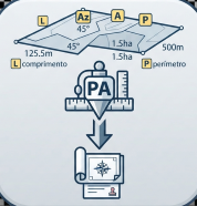
Plugin con herramientas para cálculos topográficos avanzados, incluyendo cálculo de azimuts, rumbos, distancias, áreas y generación de reportes.
About
Este plugin proporciona herramientas profesionales para cálculos topográficos en QGIS, incluyendo análisis de líneas y polígonos con múltiples opciones de exportación.
| Author | Omar Ruelas Santa Cruz |
|---|---|
| Downloads | 5,010 |
| Latest version | 1.1a |
| Last updated | 2025-05-29 (504 days ago) |
| Min QGIS | 3.16.0 |
| Max QGIS | 3.99.0 |
| QGIS 4 ready | No |
| Maintenance | Quiet |
| Categories | Raster & terrain, Georeferencing & CAD |
| Tags | area, bearing, topografía, azimut, distancia, rumbo, cálculos, área, topography |
Homepage · Repository · Issue tracker · Official page
Alternatives in Raster & terrain
- Profile toolQGIS 4 ready
Plots terrain profile
- Qgis2threejsQGIS 4 ready
3D map visualization and web export powered by three.js JavaScript library
- SRTM-DownloaderQGIS 4 ready
Downloads SRTM Tiles from NASA Server


Related plugins
- Magnetic DeclinationNot QGIS 4 ready
Calculates the magnetic heading from a true geographic heading and vice versa.
- Parcel Annotation ProNot QGIS 4 ready
Automatically annotate parcel polygons with side lengths, area, perimeter, bearings, azimuths, vertex numbers and parcel information. Built
- YF GIS Amazonia ToolsQGIS 4 ready
Suite de 18 herramientas GIS para catastro, gestion forestal y topografia en la Amazonia peruana.
- RMCGEOQGIS 4 ready
Geospatial toolkit with drawing tools (azimuth, bearing, offset, extend, chamfer), coordinate operations, and attribute table calculators.
- Precisa — CotasNot QGIS 4 ready
Generates length, azimuth, area and perimeter labels rotated along vector feature segments.
- GeoDipQGIS 4 ready
Automates the plotting of structural geology measurements (Dip and Dip-Direction).





Maintenance: Active = updated within 1 year, Quiet = 1–3 years, Likely abandoned = over 3 years.