
Home › Raster & terrain › Stereoplot

Stereoplot QGIS 4 compatibility
QGIS 4 ready Active
Yes — Stereoplot supports QGIS 4 (declared max version 4.99.0).
Interactive stereographic projection plotting and analysis tool for QGIS
About
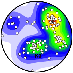
Displays geologic structural data on equal-area stereonets and rose diagrams. Supports: - automatic structural data-type detection, - density contouring, - best-fit girdles, - plotting of mean or Kamb maximum orientation, - bearing-plane visualisation, - kinematic arrows, - attribute-based classification, - category styling, - dynamic filtering using QGIS expressions and by data live selection on plots, - interactive category visibility controls.
| Author | Julien Perret (UWA-CET) & Mark Jessell (UWA-CET) |
|---|---|
| Downloads | 1,122 |
| Latest version | 1.0.1 |
| Last updated | 2026-09-01 (45 days ago) |
| Min QGIS | 3.0.0 |
| Max QGIS | 4.99.0 |
| QGIS 4 ready | Yes |
| Maintenance | Active |
| Categories | Raster & terrain, Spatial analysis |
| Tags | kinematics, stereonet, geology, qgis, rose diagram, structural geology, planes, lineation, stereoplot, contouring |
Homepage · Repository · Issue tracker · Official page
Alternatives in Raster & terrain
- Profile toolQGIS 4 ready
Plots terrain profile
- Qgis2threejsQGIS 4 ready
3D map visualization and web export powered by three.js JavaScript library
- SRTM-DownloaderQGIS 4 ready
Downloads SRTM Tiles from NASA Server


Related plugins
- GeoStereonetQGIS 4 ready
Industry-grade interactive stereonet plotter for structural geology. Plots planes and lines on Schmidt/Wulff nets with Kamb density contouri
- Structural Families MapperQGIS 4 ready
Structural geology workflow: CSV/Excel import with QA/QC validation, GeoPackage layers with geological symbology, Rose/Schmidt/Wulff diagram
- StereonetStudioQGIS 4 ready
Professional stereographic projection (stereonet): polar/equatorial grid, poles, density contours, rose diagram, kinematic analysis (planar
- GeoTrace2Not QGIS 4 ready
A QGIS plugin for geological mapping
- Sec InterpQGIS 4 ready
Data extraction for geological interpretation
- GeolAttitudeQGIS 4 ready
Plugin for for interactive estimation the attitude of geologic planar features from DTMs. Implements user-selectable fitting methods and unc




Maintenance: Active = updated within 1 year, Quiet = 1–3 years, Likely abandoned = over 3 years.